
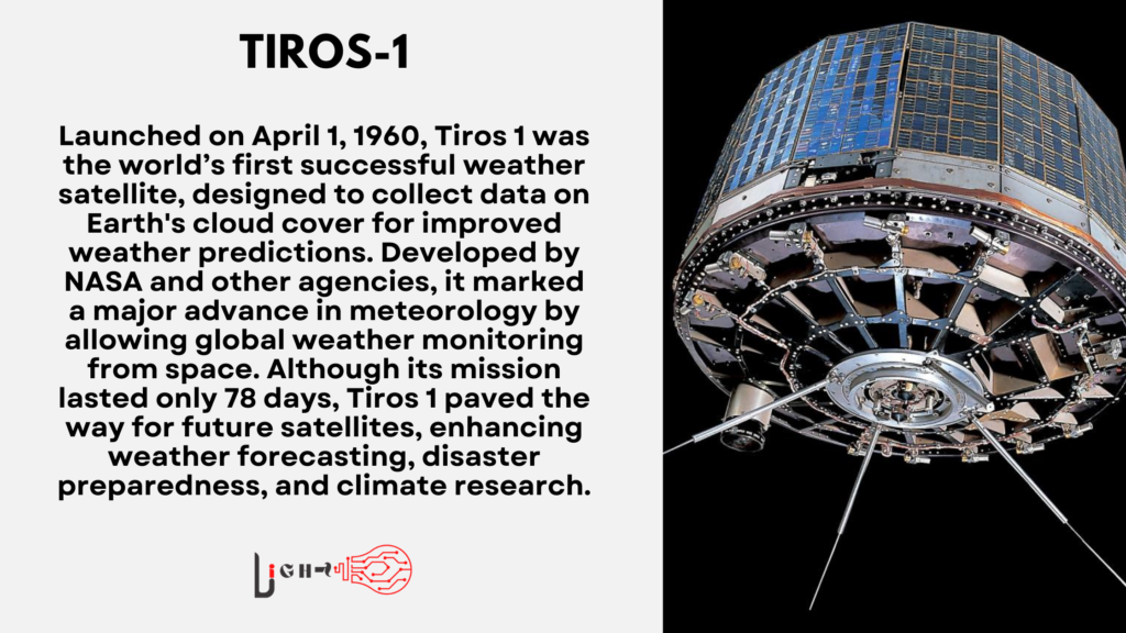
Tiros 1, launched on April 1, 1960, was the world’s first successful weather satellite. Its mission was to collect data on Earth’s cloud cover to improve weather predictions. Before Tiros 1, meteorologists primarily relied on ground-based observations, which often lacked accuracy, especially for areas over the oceans. The satellite brought a significant leap in our ability to monitor global weather patterns from space.
Tiros 1 was developed by NASA in collaboration with several agencies, including the U.S. Weather Bureau. Its ability to capture images of Earth’s atmosphere from space made it a landmark moment in both space exploration and meteorology. With only a short lifespan of 78 days, Tiros 1 set the stage for future satellites that would improve weather forecasting, disaster preparedness, and climate research.
Even though its mission was brief, Tiros 1 laid the groundwork for future advancements. This early success proved that satellites could be effective in gathering and transmitting data back to Earth. The satellite also helped refine the design and functionality of future weather monitoring systems.
The Development of Tiros 1
The development of Tiros 1 began in the late 1950s, at a time when both the U.S. and Soviet Union were racing to advance space technology. Unlike many other satellites of its time, which focused on communications or military reconnaissance, Tiros 1 was designed with a peaceful, scientific mission in mind.
NASA partnered with RCA, a leading electronics company, to create a satellite capable of taking photographs of Earth’s cloud systems. The goal was to improve weather forecasting and prevent disasters like hurricanes and severe storms from causing unanticipated damage. Tiros 1 used two television cameras to capture images, which were then transmitted back to Earth in real-time. Although the satellite’s technology was considered advanced for its time, it had to be launched into a low Earth orbit to ensure successful data transmission.
The success of Tiros 1 was also a testament to the growing collaboration between government agencies, private companies, and research institutions. Each played a critical role in advancing the technology needed to make weather satellites a reality.
Tiros 1 Launch and Key Achievements
On April 1, 1960, Tiros 1 was launched from Cape Canaveral, Florida. Weighing 270 pounds, the satellite was equipped with two cameras that transmitted images of Earth’s atmosphere to ground stations. The images were groundbreaking, offering meteorologists their first opportunity to observe cloud formations and weather patterns from space.
One of Tiros 1’s major achievements was its ability to capture the development of storms over oceans, which were previously difficult to monitor. It also provided a new perspective on weather systems, enabling more accurate forecasts. Though Tiros 1 only operated for 78 days, it transmitted more than 19,000 images, giving scientists invaluable insights into the planet’s climate.
The success of the mission confirmed that satellites could be used to observe Earth’s atmosphere from space, leading to a series of weather satellites that would follow in its footsteps. It was a remarkable achievement for space technology in the 1960s and laid the foundation for modern satellite meteorology.
Jyothi Venkitachalam :A Pioneer of Women’s Empowerment in India
To know more click here:https://light.vintbit.com/general-knowledge/journey-of-jyothi-venkitachalam/
Impact on Weather Forecasting
The launch of Tiros 1 marked the beginning of a new era in meteorology. Prior to this, weather forecasting relied heavily on limited ground-based data, which often failed to capture the complexity of atmospheric patterns. The satellite’s ability to provide real-time images of cloud cover allows meteorologists to make more accurate predictions.
Tiros 1’s impact was especially felt in monitoring hurricanes and severe storms. Before weather satellites, tracking storms over the ocean was a challenge, but the satellite provided valuable data that improved both the timeliness and accuracy of warnings. This helped save lives and reduce property damage in storm-prone areas.
In addition to storm tracking, Tiros 1 also offered insights into global climate patterns, contributing to early climate research. Its legacy continued as later satellites expanded upon its capabilities, making weather forecasting one of the most advanced applications of space technology.
Legacy of Tiros 1 in Space Exploration
Tiros 1’s success not only impacted meteorology but also set the stage for future space exploration missions. The satellite demonstrated that space technology could be used for peaceful, civilian purposes beyond military or political objectives. It inspired the creation of more sophisticated weather satellites, as well as earth observation systems that are still in use today.
As the first in a long line of weather satellites, Tiros 1 showed that consistent, reliable data could be collected from space. Its short operational period highlighted both the challenges and potential of space exploration in the 1960s. This mission marked the beginning of a global effort to monitor Earth from space, an endeavor that continues with satellites today.
Beyond weather forecasting, the success of Tiros 1 influenced other scientific missions that aimed to observe Earth’s environment. It became clear that satellites could help solve practical problems on Earth, such as disaster management, climate monitoring, and environmental research.
Conclusion
Tiros 1 was a pioneer in many ways. It was the first satellite to successfully capture and transmit images of Earth’s weather systems, revolutionizing meteorology. Its data helped shape the modern understanding of atmospheric dynamics and influenced the development of future satellites.1
Though its mission was short-lived, Tiros 1’s contributions to both space exploration and weather forecasting remain invaluable. It stands as a symbol of how early space missions could have a direct, positive impact on everyday life by improving the accuracy of weather predictions and saving lives. The legacy of Tiros 1 continues to be felt in modern weather monitoring and space science.